Posting out of order, but it’s better than nothing….right?
1/2 day off work and off to the hill. The forecast looked great, driving to the hill confirmed the forecast.
Driving up the hill and the LZ field had dust devils all over, Oh boy, wish I was here sooner! Setting up it looked incredible!
No driver today, but conditions looked great for an out & return. I was about 5-6 miles into the wind towards Oaksdale when Rick showed up. He started setting up and noticed an issue with a corner bracket. (Had a crack) I asked him if he wanted to go for a drive & play some chase since he couldn’t fly, he said sure.
I hung a U-turn. (the wind was getting stronger anyway so this worked out really good) Back at the hill I was a bit low. How ironic I thought to myself. Have a driver now & the day isn't going to work. I pushed on and a mile past the hill I catch a slow climb. Well, the day was really good, but that’s changed it felt like. We figured I could maybe run to the CDA casino. Climbs were weak, & not very high. Sky was also getting filled in.
Just past the casino I get another good climb, ok the day is still working. I keep telling Rick, “move up the road 10 miles & we’ll see how I’m doing” (This would go on most of the flight.)
Getting low near CDA I get a great climb out. This is such a good late Sep day! Near Athol the same thing, back up and gliding
Nearing Sandpoint ID, it looks like I have just enough to get across. As I start across the lake, beep beep beep. Sweet! Back up to 8400’ msl. This would be the last climb, leaving me a final glide of around 15 miles.
1/2 day off work. Late start. Rough getting going & getting a climb out. Under dressed, froze my arse off. Only the 2nd time I've got to 12000' in this area. Very unusual. Tough going on the last leg. Thought I would be landing out. Found a little something to get me up and kept going. My largest FAI triangle from this site, 87 miles Flight track log
6-13-15
Had some big plans for the great forecast. Parker to Grangeville, about 180 miles open distance. There is the Spokane airspace one must divert around one side or the other.
(You could chance going over the outer ring at 6400 msl, but if you got low.... not worth the risk)
My decision was to stay W and go by Reardan. I have flown through there before. I had some LZ ideas if needed.
Cues formed early. Arriving in the LZ there were some big cycles going through.... uggh I was late.
Got set up, and tried to launch.... many many times. (Burned more than a 1/2 hr trying to launch safely)
There was a good amount of right cross wind in it. This launch, due to the steep face gets rotary air easy when not coming straight in.
Time and time again I would move up to the edge but could not keep the glider level. Finally had to change tactics, wait for a lull, wait for when I thought a cycle "was coming" and runoff into just a trickle.
This worked, but no room for error at this site.
Off and running, 1:30 now, about an hr late it felt like. Big blue gap to cross. Halfway to Springdale, I was down to 5700' msl. Wasn't the start I was hoping for but I was going for it.
After trudging through the area it picked up and got better. Strong climbs, good clouds.
Got down to 5600' again near Lamont, it was getting late, almost 5pm and the area is sooo green.
Clouds were drying up. Had to make sure I didn't try to rush things.
Near Pullman I knew that Grangeville wasn't going to happen (I knew a bit before than, I really only acknowledged it to myself then)
Now what to do? Opt for landing close to town to hitch a ride? (I had no driver for this flight, but the forecast was to good not to go for it)
I opted to push on, out into the farm land with sporadic farms hoping for the best if landed out.
A smallish bump of a hill was before me, go for it or turn back to land near a road?
The other side was a lot of field......
On I went, catching a climb at the hill, it was slow, but it got me another 500'. Now I could make a good LZ
(I thought was good, it was a few weeks ago)
Get small and glide well, I told myself. The #'s were showing -100' to +100' arrival height. Caught a small climb near the end to guarantee my LZ.
Arriving there I didn't scout it out because I had landed there previously and it was short alfalfa. The wind had been switching near the end of the day and I was really trying to figure out what it was doing.
I paid no attention that it was wheat and tall. I dropped 2 wind streamers that both pilled. (I would find out due to the tall wheat) Set up to land the direction the wind had mainly been all day.
Ended up tailwind with a hard arrival ;-( Just a bent weak link.
Very lucky. The wheat cushioned the glider I think.
Almost 7pm and I make some calls. My very good friend offered his truck, my outstanding girlfriend just after getting off work, picks up the truck, goes to the store for food and beer and makes the 2 hr drive to retrieve me. Arriving almost at midnight. Getting home near 2 am. Great girlfriend!!
I cant say thank you enough!!!
My alarm goes off on this early Thursday am……… no, not for work, to get gear packed to return to the “Mansfield encampment”.
(What is that? Just ask Martin: “For the past 18+ years I have based my summer vacation of flying out Mansfield Washington (for many years, nick named the “Mansfield Encampment”). Flatland flying in what is commonly known as Washington State’s “Columbia basin” can be some of the finest cross country flying to be had anywhere in the world. Every year, while my primary goal is to fly safely and enjoy the spectacular air of this area, my secondary goal has always been to try and best my previous years personal best On Line Contest scores”)The previous day while I was at work, I followed Martin’s Spot track on his epic huge flight!
I was thinking for sure he was going to get the “mythical” 300km FAI triangle that I have heard stories and adventures of chasing after it in previous years. (Invaluable knowledge can be obtained from all these flights, attempts, out landings, and “there I was” stories)
The lay of the land ….. and do’s and don’ts are all there…. one just needs to listen)
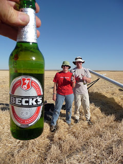
Back to packing, the local store in Mansfield we drank out of (the previous week) our favorite “washing the dirt out of our mouth” beverage ….. “Becks”
So, I'm off to the local store to pick up some Becks to bring with me and low and behold…. none. “Are you F’ing kidding me?”
Off to store # 2…..“ we don’t carry that” …………. shit!!!!
OK “Google”…..
finally, 2 case of Becks (unbeknownst to me there were 3 N/A Becks in there……(jerks) thanks for that. We will find someone to give them to later
On the road and running behind, arriving at Mansfield to find it seems I'm ok on time. A “hello, how do you do” ….load up the truck and off we went. Setting up, trying to plan “something- big-ish” I was thinking of a 275 km, Martin chimes in “looks similar to yesterday, have a go at the “300” Yeah ok I thought to myself. (No way could I fly 8 hrs. I've seen Martin’s track logs before, and the time it takes to do it. I didn’t think I was up to the task)
Feeling it was late ….12:40 on tow with lots of smoke. (should be able to get good and established though) I had a long tow, about 5.5 miles. (Half way around course it felt like
Towed through a section of 400 fpm down… on tow! Oh boy….. what will the day bring?
25 min later on glide over 12,000 asl it was looking great. Strong climb, very smooth. Get going now, I kept telling myself, you are going to run out of day with the smoke.
After passing “Wilson creek” (really never gotten past it before) I was in new territory. What did Martin say all those times going this way…..?
A bit of a blue hole to get through to Lind, “this area can be hell” I remember hearing. The smoke had really taken the edge off the very strong climbs so far. This blue area though,…..didn’t have much smoke. It ended up being very rowdy and broken.
Once close to Lind and the edge of the cues it was a rodeo. On the radio I asked Martin how I was on time. “By 3pm you need to be moving to your next TP”
Working this rowdy stuff till 3:15, time to go.
I was about 5 miles short of Lind. My thinking was I could maybe extend it N past Davenport to compensate.
Pushing NE that way things settled down, more smoke and smoother climbs. Clouds were still looking good and gave me something to fly fast to.
A hole to jump to Davenport but it wasn’t too bad. I nice high climb allowed me to glide most of it.
How am I looking for time I asked Martin, “about 5 pm you need to be pushing towards home” he said.
I pushed about 4.5 mile N trying to make up for the Lind short turn point. On towards home now at a little after 5
Now you need to change gears I told myself from lessons past. Don’t get in a huge hurry, but don’t dilly dally (landed on the E side of the lake a few times from this), there's work to do. Still about 64 miles back take off to close.
Lots of smoke but some nice clouds helped me to pick some good lines.
The day was decaying, I had caught up with Mia shortly before the edge. I had had some good lines and clouds to help guide me. She was just enough behind that she didn't fare so well.
She has a huge struggle and work ahead…..
Looking back the clouds, they were receding
(Come on Mia, you can make it!)
I was able to push an Extra 8.5 miles to the NW to help extend my distance
Final glide back to the take off area yielded a very nice sunset.
At this time, I really had no clue as to what my flight actually was. It wasn't until uploading it that made clear it was a 311 km (193 mile) FAI triangle!!!!!!!! The largest distance flown in WA state, and what is believed to be the largest FAI triangle in N America. Martin, just the day before had this title!
Two back to back… huge, amazing flights. Both flown with a fair amount of smoke. This place is amazing.
Mia and I both rendezvoused with Martin in the LZ where he had Becks and ground conditions waiting for us.
Excellent nose up landings and a beautiful sunset to break down with.
Special thanks goes to Martin and Mia for the towing and all the local knowledge a person can take in. It was this that made it possible to attempt, let alone accomplish.
I had the perfect conditions, and the knowledge of where to go to make the best of that. Thank you!
This is my personal best for distance, duration and a few hundred feet short of my highest altitude.
Mia also had her personal best for distance and duration.
What a spectacular day! My flight track logPictures from the flight
Forecast looked great. I had an idea for a destination, LA Grande OR. It would have been about 140 miles. Loaded a few waypoints on the sd card and we loaded gear and were off to the tow rd.
As the area does some days out there, we chased the wind, trying to find a direction to tow. Each spot it was a different direction. Finally settled and committed to a spot, we set up. (about an hr we lost)
Dust devils were abundant. Jorge towed first, pinned off into a nice one and was off to a great start. I had a good tow but nothing to release for, used most of the line and "had" to release. Back to the setup area and down to 900' agl I found something. A bit of a struggle as it organized yet eventually turned into a solid 900-1000 fpm. Great dust devils till about Connell area. Caught up with Jorge there.
Now to go to the left or right of the Tri-Cities airspace? Lets stay left as it looked like a better line I thought.
Across the snake river, we groveled around finding some light elusive hard to follow lift. We were down to around 5300' asl. Eventually we locked on it and got back up to 9400'
Near Touchet WA we separated, I had hung to a light drifting climb. Jorge would find another not to long after, but ended up going more to the E than I took.
Not much left in the day, hung on to what I could and scratched a few more miles out of it passing Helix OR. Basically a final glide after that, but a buoyant line it was. More E in the wind direction than I thought when I landed, didn't think it was going to come out so good, but fortunately it did.
Michele (THANK YOU!) wasn't to far behind picking up Jorge then myself. 3.5 hrs later we were back home. My track Jorge's track
Found more wind than forecast. Lift wasnt very high. Didnt think much of the day as producing a big flight. It was very rough. I wanted to land about 16 miles onto the flight and was told it was "very active" on the ground "(big dustys all over the place")…………… I guess I'll tough it out. Glad I did.
Kept grinding away at it thinking "well I can try for Athol" and thought I was going to be landing there as I approached it. Still a bit of alt left I knew there was a nice field I've landed at before near Cocolalla lake. Getting there, found a slow climb giving me enough to work towards Sagle ID.
Arriving at the edge of the lake I thought that was it for the flight. I was low, there was cloud cover, wind had picked up a bit more. Had a nice LZ picked out, Theresa was there and confirmed it was good (thank you ;-) I wasn't giving up and some searching and a couple of bumps lead to a climb. It was slow again with a lot of drift, as I got to the edge of the lake came the decision, push back into the wind or hang with it, hope I dont hit sink and drag my ass across low..... Onward I went, looked like I could make the fields on the other side after topping out the climb (a whopping 4900', surface is about 2100')
On the other side, the LZ I picked looked good. I was still in search mode. Found another slow drifting climb. Looked like there were some potential Lz's ahead so I pushed on.
This would continue for the next 30 miles, never getting over 5000' asl. Very stressful when flying unfamiliar areas with limited LZ's and a rigid. Thank you Theresa, for being there!


")
")
")
")